

The Greater Caucasus · Northwestern Georgia

Svaneti: Medieval Towers Beneath Caucasus Giants

Main Hubs & Altitude

Mestia (1,500m) and Ushguli (2,200m). Dominated by Mt. Shkhara (5,193m), Georgia's highest peak.

Road Access

Paved highway from Zugdidi to Mestia. High-clearance vehicle recommended for high passes.

Best Season

Trekking: late June to late September. Skiing: January to March (Hatsvali & Tetnuldi).

Cash & Connectivity

ATMs operate in Mestia only. Bring cash for remote villages. Magti 4G works across main valleys.

The Unfiltered Reality: What to Expect Before You Pack

Svaneti is not an easy weekend escape. Reaching Mestia requires winding through deep gorges for hours, mountain weather shifts within minutes, and high passes remain choked with snow well into June. In peak August, Mestia’s central streets buzz with tourist crowds, while remote hamlets still operate on strict mountain rhythms where roads turn to mud after heavy rain.
Go anyway.
This is one of the few corners of Europe where medieval life never turned into a museum relic. The defensive stone towers dominating every settlement were built between the 9th and 13th centuries by the direct ancestors of the families who still live beneath them. The Svans preserved their unwritten language, archaic polyphonic chants, and strict customary laws through centuries of isolation.
Whether you come to cross high alpine passes beneath Mount Tetnuldi or stand beneath the sheer wall of Shkhara, Svaneti demands respect, proper logistics, and adequate time. Give it at least four to five days—rushing through this terrain is the most common travel mistake.

Two Sides of the Range: Upper vs Lower Svaneti
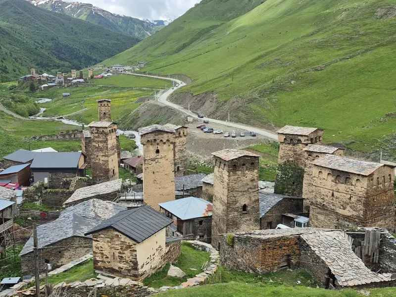
Upper Svaneti (Zemo)

Main Hubs: Mestia (1,500m) & Ushguli (2,200m)

The iconic postcard landscape with dense defensive tower clusters beneath snow-capped 5,000-meter peaks. Offers paved road access to Mestia, modern hotels, ski lifts, and trailheads for the classic 4-day Ushguli trek. While central Mestia gets busy in peak August, wild authenticity thrives in side valleys like Adishi and Mazeri.

Lower Svaneti (Kvemo)

Main Hub: Lentekhi (800m)

South of the Svaneti Range, receiving less than 5% of regional visitors. Characterized by lower elevations, dense forests, and solitary towers. Offers basic family homestays without mass tourism. Best suited for experienced adventurers crossing the rugged Zagaro Pass (4×4) or trekking the remote Latpari Pass.

Getting to Svaneti: The Real Road & Flight Logistics

Reaching Upper Svaneti has fundamentally changed with the modern paved highway from Zugdidi, but navigating high mountain passes still demands respect, weather awareness, and realistic timing.

Tbilisi & Kutaisi to Mestia: The main artery runs via Zugdidi along the Enguri Dam. It is fully paved and accessible by standard car year-round, though heavy rain can trigger rockfalls. Expect an 8–9 hour drive from Tbilisi or 4.5–5 hours from Kutaisi.

Mestia to Ushguli Road: The route is paved for most of the way, but the final stretch into Ushguli turns into rough, unpaved terrain. High-clearance vehicles are strongly recommended.

Zagaro Pass (Lower Svaneti Link): Connecting Ushguli to Lentekhi over the 2,620m Zagaro Pass is strictly 4×4 territory. The pass is open only from late June to mid-October.

Flights via Vanilla Sky: Small passenger planes fly from Natakhtari (Tbilisi) and Kutaisi to Mestia’s Queen Tamar Airport. Tickets sell out weeks in advance and mountain flights cancel frequently due to weather. Always keep a flexible road backup.

Key Villages & Valleys of Upper Svaneti

Svaneti is far more than central Mestia. The soul of the region lives in isolated communities tucked into lateral alpine valleys beneath towering glaciers.

From the living medieval citadel of Ushguli to the quiet, wildflower meadows of Mazeri beneath Mount Ushba, choose your base strategically based on whether you want classic trekking, remote solitude, or winter skiing.

How to Choose Your Base:

  • For First-Timers: Mestia provides modern infrastructure, ATMs, tour operators, and direct paved roads. Best for day trips and museum visits.
  • For True Solitude: Base yourself in Mazeri (Becho Valley). It remains untouched by heavy tourism, surrounded by alpine pine forests beneath Mount Ushba.
  • For High-Altitude History: Ushguli gives you immediate sunrise views of Mount Shkhara and an authentic, rugged atmosphere once day-trippers leave at 4 PM.
  • Road Reality: While Mestia is an easy drive, lateral valleys (Adishi, Ushguli, Zagaro) require 4×4 vehicles or experienced local drivers.

This is the heading

Lorem ipsum dolor sit amet, consectetur adipiscing elit. Ut elit tellus, luctus nec ullamcorper mattis, pulvinar dapibus leo.

Ushguli (2,200m)

UNESCO citadel of Chazhashi under Mount Shkhara. Rough dirt road access.
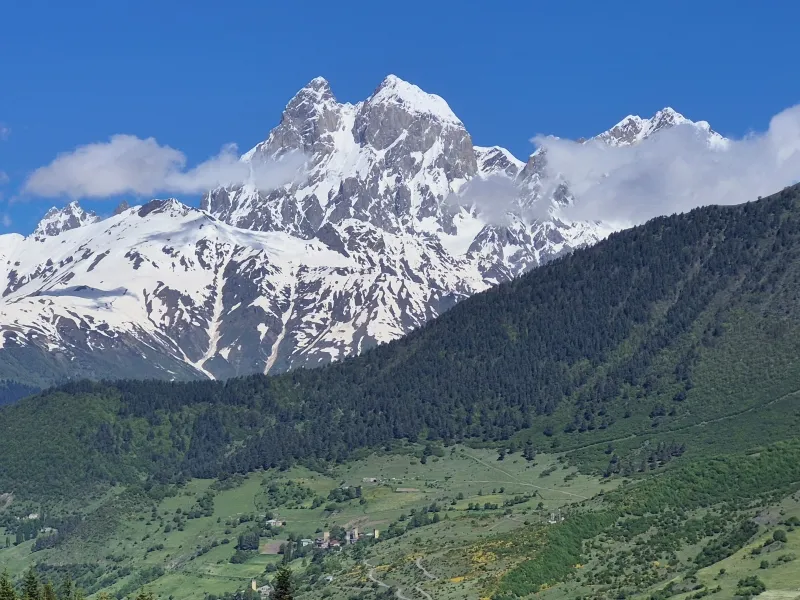
Panoramic mountain landscape between Mestia and Ughviri Pass in Upper Svaneti

Mount Ushba Viewpoint

Unobstructed views of Mount Ushba's twin peaks from the scenic road out of Mestia towards Ughviri Pass.
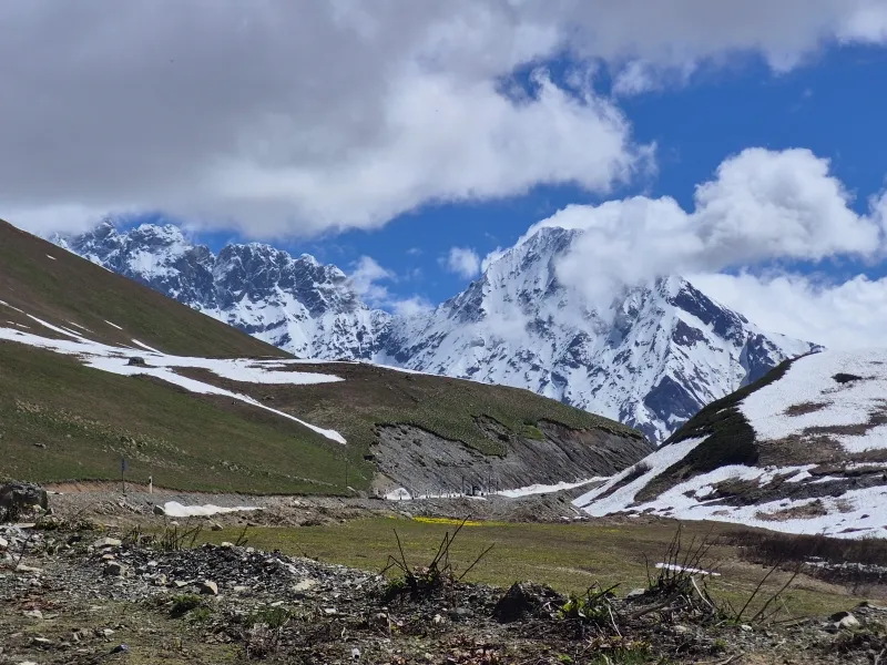
Snow-covered mountain pass road in Upper Svaneti Caucasus

High Alpine Passes

Rugged terrain above 2,500m connecting remote communities like Ushguli and Zagaro Pass. Strictly 4x4 territory.

Iconic Hikes & Trekking Routes in Upper Svaneti

Upper Svaneti is Georgia’s premier alpine trekking destination. Trails range from easy half-day valley walks to demanding multi-day pass crossings. The core hiking season runs strictly from late June through late September; attempting high passes earlier means knee-deep snowpack and swollen, hazardous river crossings.

Mestia to Ushguli (4 Days)

• Distance: ~58 km | Difficulty: Demanding
• Highlights: Adishi, Chkhunderi Pass, Ushguli

The classic Caucasus trek connecting remote stone villages through high passes. Requires wading the Adishischala glacial river. Village guesthouses eliminate the need for tents.

Shdugra Waterfall & Ushba Trail

• Distance: 12 km | Difficulty: Moderate
• Duration: 5–6 hours (from Mazeri)

Georgia's tallest waterfall fed directly by Ushba Glacier. Trails climb from tranquil Mazeri pine forests past a border post to the granite basin beneath Mount Ushba.

Chalaadi Glacier Day Hike

• Distance: 5 km | Difficulty: Easy
• Duration: 2.5 hours (from bridge)

Mestia’s most popular day walk. Crosses a footbridge over the river, enters pine and boulder forests, and reaches the terminal ice moraine. Beware of rockfall near the ice.

Explore Svaneti With Us: Guided Treks & 4x4 Expeditions

Whether you are looking for a fully supported multi-day trek between medieval stone villages or a rugged 4×4 mountain expedition crossing high alpine passes, we provide experienced local guidance, reliable mountain vehicles, and seamless logistics.

Classic Mestia to Ushguli Guided Trek

• Duration: 4 Days / 3 Nights
• Route: Mestia – Zhabeshi – Adishi – Iprali – Ushguli
• Included: Professional guide, luggage transfers, horse assist at Adishi river, family homestays.

Experience the premier alpine route of the Caucasus with complete peace of mind. We handle river crossings and luggage while you trek unburdened.

VIEW TREK DETAILS

Upper Svaneti & Zagaro Pass 4x4 Expedition

• Duration: 3 to 5 Days (Flexible)
• Route: Enguri Dam – Mazeri – Mestia – Ushguli – Zagaro Pass – Lentekhi
• Included: High-clearance 4x4 vehicle, experienced mountain driver-guide, fuel, flexible trailhead transfers.

Traverse the entire Svaneti loop, from the deep Enguri Gorge to the 2,620m alpine wilderness of Zagaro Pass, safely navigated in fully prepared 4x4 machinery.

REQUEST 4X4 ITINERARY

Frequently Asked Questions: Upper Svaneti Travel

Do I really need a 4x4 to visit Svaneti?

For the main paved road to Mestia, a standard 2WD vehicle is fine. However, reaching Ushguli, crossing Zagaro Pass, or accessing remote trailheads (Adishi, Mazeri valley base) requires a high-clearance 4×4 vehicle and experience with mountain terrain.

The primary hiking season runs strictly from late June through late September. In May and early June, passes above 2,500m (like Chkhunderi) remain blocked by hazardous snowpack and glacial rivers run too swollen to cross on foot.

It is rated as moderate to demanding with daily ascents of 800–1,000 meters. However, village guesthouses along the way eliminate the need to carry tents or heavy cooking gear—you only need a daypack.

Mestia has reliable ATMs and card terminals. Beyond Mestia (Ushguli, Adishi, Iprali), card readers rarely work and there are no cash machines. Carrying Georgian Lari cash is strictly necessary.

Natural high-altitude springs and village tap water are generally clean. Never drink from open valley streams near grazing livestock. Carrying a compact water filter or purification tablets is recommended for long passes.

Magti offers reliable 4G coverage in Mestia and most villages. Deep gorges and high mountain passes have zero reception. Guesthouse Wi-Fi is common but can be slow during storms.

Ready to Plan Your Upper Svaneti Adventure?

Whether you need a dedicated 4×4 mountain driver, luggage logistics between trailheads, or an experienced local guide, let’s build an itinerary tailored to your dates and trekking pace.

Scroll to Top